|
Ring of Fire Iceland, May 22-June 3, 2003
What can I say about 12 days in Iceland? Twelve days of waterfalls, rainbows, mountains, glaciers, geysers, explosion craters, lava fields, steam vents, hot tubs, sheep, Icelandic horses, ducks, seagulls, arctic terns, and the Arctic Circle. Anyone can see all of those on a trip to Iceland, but there also was something that won't be repeated there for decades, a Ring of Fire hanging in the sky — an annular eclipse of the sun.
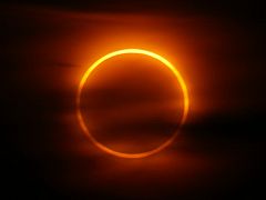
I was on a cliff above Eyjafjörður fjord in the village of Ólafsfjörður, northern Iceland, at 3:59 a.m. on May 31, 2003. At that moment the moon was almost entirely in front of the sun, but I couldn't see it. Between 3:27 and 3:35, there had been a decent look at a partial phase of the eclipse, but then a frustrating layer of clouds seemed sure to ruin the view of the annular (ring) phase. At the last possible moment, 4:02, the clouds thinned out enough so the Ring of Fire could be seen, faint but visible. Two minutes later the view of the perfect ring was still faint but visible, and two minutes after that the annular phase was over. Eclipses don't come along that often, and to get any sort of view is something special. You can read more about the eclipse (how does an annular eclipse differ from a total eclipse anyway?) or you can follow along on the rest of my journey. "You Must Be O'Neil" Some travelers describe an immediate sense of awe on landing in Iceland. The area around the airport is desolate, almost a moonscape. Like most of the rest of Iceland, there are no trees. Having grown up in South Dakota and thus being something of an expert on desolation, I didn't feel the awe right away. Or perhaps at 6:30 a.m. I was still in a fog after getting 15 minutes of sleep on the crowded overnight flight from Boston. Whatever the reason, it took a while for what I was seeing to start sinking in. As I guided the VW Golf rental out of the parking lot, relearning manual shifting on the fly, I soon found myself on a road surrounded by a lava field. However the field was mostly green and rounded, not black and jagged. It wasn't until I stopped and took a closer that it became apparent the lava was covered with a thick layer of moss, with the black rock only sticking out in spots.
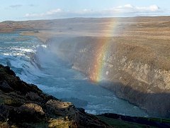
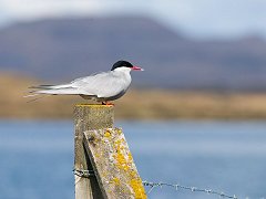
It would be candid of me to admit that technically I got lost right away. Rather than drag out my notes and the map they were based on, I relied on the rental car map and my memory. Since the maps were on different scales, I turned south too soon. It seemed OK as I reached the coast and turned eastward. The first sight I saw was a large cliff populated by lots of arctic terns pinwheeling around, apparently a nesting area. My cameras were in the trunk and I needed to get them out, which doesn't sound like a big deal, but terns are known for their aggressive defense of nesting areas. I accomplished my mission quickly and managed to escape harm. Back in the car, I took a few shots through the open window then drove on. I saw no other cars on that stretch of 23 kilometers, which is not surprising since the road was quite steep and not in very good shape. At one point I turned toward what I thought might be more bird cliffs. It is so hard to judge distances without a few trees around as reference points. At an impassable spot in the road I stopped and hiked toward the coast, but after a while it didn't seem like I was getting close to anything so I returned to the car and drove back out. It wasn't until I reached the thermal area at Krýsuvík that I figured out I had been on the wrong road and wasn't as far east as I had planned. After Krýsuvík the road was better but still unpaved in spots. I was getting snoozy and had to pull over a couple of times. Around 2:00 p.m. I reached my lodging at Skálholt, which is the Church of Iceland conference facility. Their web site says tourists are welcome and they charged a lot less than comparable hotels, so it was a good deal. I couldn't find anything resembling a reception desk so I hailed two women who were vacuuming the hallway and asked about lodging. The taller one responded, "You must be O'Neil." The suspicions aroused by that statement were confirmed when she said I was the only guest that night. The room seemed a little spartan with two single beds and a fairly small bathroom, but I found out that it was quite comparable to the hotel rooms I would have at every other location except Reykjavík. I took a four-hour nap to combat the effects of the overnight flight and awoke at 7 p.m. ready to do some scouting for the next day. I drove past Geysir and saw the steam rising from the thermal areas, but wanted to get to Gullfoss (the "Golden Waterfall") first. Gullfoss is a double-decked waterfall with a 90-degree turn in the middle. It was quite impressive and had a rainbow over it, but most of the falls was in shade and since I was coming back the next day I didn't worry about getting photos. When I got back to Geysir, it also was in shade so I didn't bother to check out the geysers. However, I did have dinner at the hotel there, then headed back to Skálholt just as the sun was setting at about 10:30 p.m. Even after sunset it didn't get very dark. Since there was no one else in the building, it was very quiet and spooky. It was only later that I found out that the last Catholic bishop of Iceland was executed there in 1550. They don't put that in the brochure! Perhaps the ghost of the bishop, Jon Aronson, haunts the place. The Golden Circle Caution! Baseball analogy ahead. In 1983 the Hall of Fame pitcher Bob Feller made an old-timers game appearance in the quiet (most of the time) little town where I was sports editor at the time, Sturgis, South Dakota. He was 64 and his last pitch in the major leagues was 27 years in the past, but the old Iowa farmboy still enjoyed pitching an inning against the local hackers. Never mind that his fastball was 70 mph (he said) rather than the 100 mph of his youth, that's the great Bob Feller out there and hey, doesn't he look great?
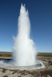
Twenty years later on May 23 one of my stops was the Geysir thermal area. The geyser which gives its name to the phenomenon, the Great Geysir, still throws off some steam but has been mostly dormant since 1930. The star of the scene is now Strokkur, "the Churn," which erupts every few minutes with brief but spectacular columns of water and steam. I positioned myself and got a photo of Strokkur erupting with a snow-capped mountain in the background. However, the wind was blowing directly toward me and I suddenly realized that water was going to be coming down on me like rain. No time to escape so I turned my back and braced for what I hoped would not be a boiling-hot shower. To my shock the water was ice cold! The air must cool the water very quickly. It was about this time that I realized the raincoat I had bought just for this journey never made it into my luggage. I was a little wet but after a few minutes I decided to try one more shot. This time there was a lot more water in the deluge and I got really soaked. After that I sat down at a location where I could dry off and watch Strokkur do its thing. Each eruption consisted of 1-3 bursts of varying size and came every 5-10 minutes. After one small initial burst, I heard an American newly arrived on the scene say, "Is that all there is to it?" At that point Strokkur responded with two much more impressive bursts. Impatient Americans! While waiting for another burst from Strokkur, off in the distance there was a column of rising steam followed by a bubbling column of water. It was Geysir! (There is a difference between "dormant" and "extinct.") The column reached only about three meters in height compared to 70-80 meters in its heyday or 25-35 meters of present-day Strokkur, but it was Geysir putting on a show that lasted for a minute or so. His fastball is 73 years in the past but that's the Great Geysir out there and hey, doesn't he look great? Day Log: My reading mentioned some strange Icelandic foods, so I was a little leery about heading down to breakfast at Skálholt and finding nothing but sheep eyeballs, rotted shark and pickled herring. To my relief the breakfast spread was normal food such as orange juice, cereal, tomatoes, bread and salami, although there was one grayish sausage/pate that I bypassed. After breakfast I headed southwest toward the explosion crater at Kerið. One of my web sources said it was easy to miss. The source was correct; I never did find it. I abandoned the search and headed north toward þingvellir National Park where the Icelandic Alþing (Parliament) can trace its origin back nearly 1,100 years to the annual gathering of the Viking settlers. Besides being the heart and soul of the nation, this dramatic valley also is one of the few places where the Mid-Atlantic Ridge isn't under the Atlantic Ocean. To the east is the tectonic plate that bears the continent of Europe; to the west is the North American plate. After snapping a few photos of the parliamentary plain, I devoted some time to getting shots of the nearby waterfall Öxarárfoss as poured over the basalt cliff. The shortest route from þingvellir to Geysir is along Route 365, which is unpaved much of the way. The major problem with unpaved roads in this part of Iceland is that the safe speed for a VW Golf is much lower than that for a big SUV with fat balloon tires. As I was puttering along, one of those monsters roared up from behind and shot past. Shake fist, mutter expletives.
The light at Gullfoss was much better than the previous evening and there also were a lot more tourists on hand. After Gullfoss it was back to Geysir (detailed above) followed by an alleged egg salad sandwich for dinner. I drove back to Skálholt and hiked around the neighborhood for a while before heading inside. I wasn't expecting anyone to be in the facility, but as I extended my key toward the lock a distinguished-looking gentleman opened the door and said, "You must be Mr. O'Neil." Once again I was the only guest in the place. He didn't introduce himself and I didn't inquire so for all I know he was the bishop himself. He asked me if I wanted something to eat and since the "egg salad" had been unsatisfying I said yes. He rooted around in the kitchen to see what was available and came out with a salad and two sandwiches, one salami and one with the grayish stuff that I had bypassed at breakfast. Oh well, it must be edible so I ate it (without incident). By the way, Bob Feller is still with us at age 84 and as far as I can determine is still getting out to the ballpark and looking great. Standing in a Rainbow As you approach Skógar from the west and swing around a mountain, the waterfall Skógafoss looms into view. This is a fairly large waterfall that throws up a lot of spray, so when the sun is shining a nice rainbow can be seen. The sun was in and out of the clouds on this day, but at one moment when I was near the falls, the mist was all around me and so was a little rainbow. Then it clouded over and the moment was gone.
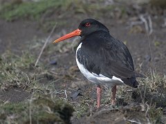
Day Log: I left long before 8 a.m. so didn't get breakfast. Selandafoss is a nice high waterfall but was in shade when I passed by so the photos were difficult. After Skógafoss I went down the road for the bird cliffs at Dyrhólæy, but as I feared they were closed for nesting season. However on that road I did get a decent closeup of an oystercatcher, which is one of many plover-type birds which frequent the island. The route to the beach at Vik was not well marked so I parked at a gas station and took off on foot. The beach is beautiful black sand, sort of like the black sand beach on the Big Island of Hawaii, the difference being the cold wind keeps the sunbathers away from this beach. The drive to Kirkjubæjarklaustur was unremarkable except the farms gave way to lava fields again. In the evening I walked about a quarter mile from the hotel to see Systrafoss, a small waterfall but in an interesting setting. Where is Everybody? After I left Kirkjubæjarklaustur and drove down Route 1 eastward for a while, I realized I had not seen any other cars. Finally 58 kilometers down the road I saw another vehicle. As I approached Skaftafell National Park, I finally saw a couple more vehicles. I could also see tongues of two glaciers in the distance but exactly how far away they were was difficult to tell. As I drove into the parking lot it looked as though one of the glaciers, Skaftafellsjökull, was just a few hundred yards away, but the sign said 1.5 km and I think it was probably further than that. It really is hard to figure out the scale of things. Day Log: As I arrived at the park and prepared to hike to see the famous waterfall Svartifoss, the rain started coming down. Without a rain coat all I could do was hope my jacket and hat wouldn't get too soaked. My photo backback was better protected than I was with its built-in rain cover. As I headed off on the uphill climb toward the waterfall, the rain got heavier. Fortunately it slacked off by the time I got to Svartifoss, but it resumed from time to time for the rest of the morning. Originally I had planned to be on the ride to the Ingolfshofdi bird cliff at 1:30 p.m., but as the time came to head over there, it looked as though the weather wasn't too good in that direction. I figured I may as well get soaked at Skaftafell where I could walk back to the car rather than 10 km out in a tidal flat waiting for a farmer with a tractor. So with the rain not too heavy I headed down the trail toward the glacier. As I said, the distance to the glacier was impossible to judge and it seemed like it was always just a few hundred yards away. Eventually I got there and heard some of the groans and creaks of the glacier, then headed back as the rain got a little heavier. I drove on toward Jökulsárlón and what a sight that is. All sorts of icebergs of various sizes and colors bobbing around in a lagoon. I took lots of photos from the west side, then took even more from the east side. As I got back on Route 1 and continued east, sheep started to become a more significant navigation hazard. I managed to avoid any incidents and eventually arrived at my lodging for the evening, Fosshotel Vatnajökull near Höfn. I thought for a while it was going to be the "You must be O'Neil" routine again, but I think there was one other couple staying at the hotel. The hotel was located in a spectacular setting within sight of two glaciers, but I didn't have any opportunity to explore the area since it was getting late. Up the Mountain A few days into the journey I thought perhaps it was a mistake to drive only as far as Djúpivogur on this day, about 100 km. However, after I finished that 100 km I was ready to take a break. Five sections of Route 1 were unpaved, all on mountainous sections, and there were very few guardrails. The drizzle didn't help either. As I was heading up one stretch with nothing to the right of me except a steep hillside leading down to a cliff and the ocean, I was wondering how many people had rolled off that road and not been found for months. I edged closer to the middle of the road and slowed down. The road was wide and there was almost no traffic, but after meeting a large truck on one of the better stretches, I was just happy I hadn't seen that thing coming down the hill toward me. After several hours of that I was very happy to stop in Djúpivogur for the rest of the day. After a short rest I went down to the rocky shore where I had seen a mass of seagulls feeding earlier. The sun had come out and I took a few shots just for something to do. There was a large herring processing plant next to where the seagulls were congregating, so it's apparent there was some byproduct that was attracting all birds. I walked past the museum and around the little harbor to a beached fishing boat to take a few shots. There were some kids playing there so I asked the woman with them if it was OK to take photos. She didn't have any objection and seemed to be wondering why I was asking her, but I didn't attempt to explain that in the US an unaccompanied man with a camera hanging around where kids are playing equals "pervert." I was tired of lugging my camera stuff around so took just the Elph on a hike up the hill behind the hotel. It was a good observation point to see the mountains, town, and Papey Island off in the distance. I would have taken a boat tour to Papey if it had been in season. Then I went to a nearby store to get rid of some of the change that had been filling up my pocket. After much puzzling over the labels, I got something called a "Lúxus" which appeared to be an ice cream bar with caramel. It was, and it was very good. I also got a can of something called "Pringles," sort of like potato chips but not really. The can says they were made in Belgium, so "pringles" must be Flemish for "processed potato extract." (I'm sorry. It was a slow day and I'm trying to stretch this out.) The hotel itself was rather interesting. The new wing is all done in pine and the hallway is very tall and narrow with a stained glass window at one end. A definite step up from the previous night's lodging. Cod for dinner again (not bad) and another leisurely walk around town concluded the day.
Singing in the Church Dimmuborgir on the east side of Lake Mývatn seemed to be just another place to make a quick stop but I ended up spending a couple of hours there. It's an area of weird lava formations 2,000 years old and has a number of hiking trails. A tour bus was unloading just as I got there, so when they went left, I went right. There are many natural arches, including one very large arch that frames the huge cinder crater Hverfell. But the most notable feature along the trails is Kirkjan ("Church"). I followed a couple of German tourists up the small hillside and into the cavern. Imagine a rocky hill, hollowed out and with two large entrances on the sides. As usual I had trouble gauging the size, but I'm guessing it is 30-40 meters across. Certainly large enough to hold dozens of people, and the guide book says they hold concerts there during the summer. After snapping a few photos I was walking back down the path when I heard singing coming from the cavern. It was the German woman trying out the acoustics. (Apparently she had been waiting for me to leave.) I didn't recognize the composition, but it sounded beautiful and devout, very appropriate for the venue. She sang a few halting words, stopped, then started again with a little more confidence. After about a minute the singing faded away. Day Log: I was thinking about taking a shortcut just outside of Djúpivogur to save 50 km but got scared off by the sign that said "17% grade 19 km ahead" and stayed on Route 1. There were more unpaved stretches of Route 1 and one hill was marked 12%, but there weren't as many scary dropoffs into the ocean as the previous day. By the time I reached the place where the shortcut would have taken me, the coastline was left behind and most of the drive to Mývatn was across open country. The empty stretch after Egilsstaðir suggests what the uninhabited interior of the island must be like.
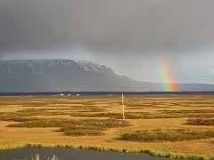
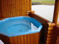
My first stop in the Mývatn area was the Námafjall thermal area at Hverarönd. There are several impressive steam vents and boiling mud pots. After my stop at Dimmuborgir I checked into the hotel, then explored the hiking trail just across the road that goes around the southern part of the lake. One of the distinctive features of the lake is a number of craters that were formed not by volcanoes but by trapped groundwater exploding up through hot lava. Many of the islands in the lake were formed this way. Mývatn means "Midge Lake," midges being annoying little bugs that buzz around your head but fortunately do not bite. Supposedly there are biting blackflies also, but fortunately they did not seem to be in season. All the bugs means plenty for birds to eat, and Mývatn is renowned for its variety of waterfowl. I didn't see a large number of birds near the trail, but I did see a couple of little waterfowl swimming among the clumps of grass along the shoreline, picking at bugs as they went. I managed to ID later them as Red-necked Phalaropes. Who makes up these names? After the dinner buffet, I felt the need to work some of it off with a very short hike to the church at Skútustaðir. The church was white against some dramatic dark clouds, and there was a rainbow off to the right. As I walked back to the hotel, the left side of the rainbow became very evident, so of course I got a few shots of that. Scenic Overload It was mostly a cloudy and rainy day as I drove a large loop through Jökulsárgljúfur National Park and the coastal town of Húsavík. Maybe it was the weather or scenic overload, but stops at the Viti ("Hell") explosion crater and Dettifoss waterfall just didn't do much for me. I continued around the Tjörnes peninsula looking for puffins but didn't see any. Húsavík seemed like a thriving little place and they have an interesting church there, but the light was bad so I didn't bother trying photos. I went back to the hotel and took a long nap before dinner. At that point it was extremely foggy and I didn't venture out. Click next. Hot Tub I know five words in Icelandic now as my journey progresses. The first one is obvious, "geysir." The all-important word for restroom is "snyrting." Yes is "ja" and no is "nei." The fifth is the word for laundry, "þvothús." Why is there an Icelandic word for something that apparently doesn't exist? One of the guidebooks suggested that campgrounds often had washing machines. The campgrounds I checked out in Djúpivogur and Akureyi were still not open for the season, so no help there. The hotel at Lake Myvatn didn't have any sort of laundry service available. Akureyi is the second-largest city in Iceland so surely they would have something besides the closed campground. The guidebook had an address for a þvothús and it was fairly easy to find. There was enough to keep me busy in the little city while waiting for my laundry and my interpretation of the sign out front seemed to indicate that they opened at 8 a.m. Since it was 10 a.m on a weekday, I was dismayed when the door was locked and there was no one around. With the premise behind my plan shot down it seemed pointless to stick around Akureyi. I just drove on, not exactly sure what I was going to do the rest of the day. Going into this trip, I calculated that I needed to find a laundry somewhere between the fifth and ninth day. So here on Day 8 the clock was running out on my clean clothing supply. As I was checking into the hotel very early (before noon) the proprietors showed me the little cabin that would be my room. I knew they had cabins but wasn't expecting one. Then when they asked whether I wanted to know how to fill up the hot tub, all I could say was, "Sure!" It turns out that ólafsfjörður like many other places in Iceland has a large supply of free hot water from a geothermal spring. According to the thermostat it comes in at 50°C (122°F), which is too warm, but after an hour or so it cools down to a very comfortable temperature. As it was cooling down I did my laundry in the bathroom sink using the Tide I had brought along, and hung things everywhere to dry. With that accomplished, I went and sat in the tub for the rest of the day, or at least it seemed that way. A few days later as I was walking around Reykjavík, I saw a sign on the side of a building that said, "þvothús." Hmmm, I remember that word. My laundry woes were behind me, but out of curiousity I went around the corner to check it out. It was indeed a laundry, and it was closed. Day Log: Overcast and foggy as I left Lake Myvatn and the light wasn't too good when I stopped at the waterfall Godafoss. I took a few obligatory snapshots but I knew nothing special was going to come of them. After my failed mission in Akeyuri, with some difficulty I found the road northward out of town. I just missed the ferry from Arskogssandur to the nearby island of Hrisey and didn't feel like waiting two hours for the next one, so just drove on. Hrisey is supposed to have some decent hiking trails but nothing spectacular. It was on to Dalvík and then the tunnel to ólafsfjörður. This is a very long one-lane tunnel through a mountain. There are frequent turnouts on the east side, so apparently the rule is that northbound traffic always yields to southbound. After soaking in the hot tub I had dinner at the hotel (fried fish, a little salty). Then it was back to the little cabin to run a little more hot water into the hot tub and soak some more. By the way, it was Sunday morning when I saw the laundry in Reykjavík so it's no surprise that it was closed, but it fit so well into the story! Circle of Ice My goal for this day was to stick a toe into the Arctic, then return safely to my hot tub in ólafsfjörður. The Arctic Circle is defined as 66°33' north latitude because that's the demarkation line for experiencing the 24-hour daylight of the midnight sun each summer. The island of Iceland is just south of the Arctic Circle, but the line runs through the island of Grimsey, 25 miles off the north coast.
Rather than fly to Grimsey from Akureyri I decided to catch the ferry from Dalvíkurbyggð (Dalvík), which is a short drive from ólafsfjörður. About 30 souls signed on to take the bright yellow Sæfari that day, probably a little less than half the passenger capacity of the ship. About 20 were family members heading to Grimsey for a wedding, and the other 10 were tourists. Vehicles, presumably for the wedding procession, had to be hoisted onto the ship with a winch and a big sling, and we were about 20 minutes late getting out of port. Sitting in harbor it was actually warm outside on the sunny top deck, but soon after we set sail the wind picked up and it became apparent that inside the main cabin was the place to be. Early in the 3.5-hour voyage when we were still in the relatively tranquil water of Eyjafjörður fjord, a lot of the kids were loading up on snacks and drinks. About one-third of the way into journey as we left the fjord and headed out into the Arctic Ocean, the pitching and rolling of the ship increased. I have been on much rougher boat rides, but the constant movement was enough to make several people nauseous. During the next couple of hours, at least three of the kids didn't quite make it out of the cabin before losing their snacks in the aisle. I'm sure they will forever associate their cousin's wedding with getting sick on the boat. I was feeling a little queasy myself, but I hadn't had breakfast and as long as I sat very still, it was OK. After an eternity, the island finally came into view, surrounded by a thick carpet of white dots bobbing up and down in the ocean. If there are 120 people on the island, there must be at least 10,000 seabirds for each person. The white dots were thousands (millions?) of birds. The port is small but has a very active fishing fleet. On the dock there were stacks of containers full of fish ready to be loaded onto the ship. As I disembarked and headed north up the hill, the wind was blowing 40 miles per hour. One of my fellow travelers commented that it certainly seemed as though we had reached the Arctic. This is another time I wish I had brought that raincoat because the hood would have helped block the wind. While hiking north along the paved road, I could see that the seagulls, arctic terns and other birds covered the land as well as the sea. The birds struggled against the wind, barely able to make headway. Eventually the road led to a guesthouse, behind which was the promised signpost marking the Arctic Circle. My GPS confirmed the latitude, and I continued on a few hundred yards just to make sure, turning back with a maximum reading of 66°33'08". As I came back to the signpost and tried to take a photo of it, the wind was whipping so hard that I couldn't hold the camera straight and my eyes were tearing up so much that I could barely see to compose the shot. This was with a temperature of perhaps 42°F. Imagine what this place would be like in the dead of winter. To the east of the signpost was the airport runway, and the wind was coming across it at a right angle. Surely the sightseeing flight had been cancelled for that day. It seemed impossible that a small plane could operate safely in such a crosswind. However, hundreds of seagulls probably thought everything was just great as they sat on one end of the runway, sunning themselves. As I hiked back south I could see Iceland through the haze, looking like an immense fortress with a great wall of 3,000-foot mountains stretching from horizon to horizon. One can just imagine the isolation felt by the residents of Grimsey, but there must be some comfort in being able to see the mainland of their country much of the time, however forbidding the appearance. I made it back to the ship an hour after landing. During the summer season, the ship stays in port for three hours, but that schedule was not in effect yet and this day's departure would be when the ship was ready to go. Although it was apparent that they were still loading fish and there was some time to do a little more exploring, I didn't feel like braving the wind again and certainly didn't want to miss the departure and get stranded on Grimsey. When I plopped down inside the cabin, the cashier offered to close the doors, but there wasn't that much wind coming through and it seemed important to get the place aired out. We set sail again after a little less than two hours in port with the 10 passengers who had not been invited to the wedding. It was a little less turbulent on the way home and there was no repeat of the morning's unpleasantness.
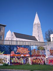
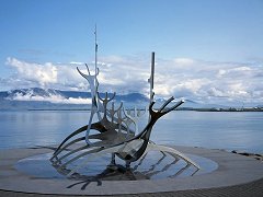
Day Log: It's 17km from ólafsfjörður to Dalvík. I left for Dalvík too early to get breakfast at the hotel, so I didn't have anything before boarding the boat. (Good thing.) After completing the boat ride, dinner consisted of some stuff I grabbed at the grocery store in Dalvík. I wanted to get back to ólafsfjörður to fill up the hot tub. Ring of Fire I've been thinking about visiting Iceland since at least 1996, and was finally prompted to action when I saw there was going to be an eclipse visible from there the morning of May 31, 2003. Click here for a complete rundown on the eclipse. Day Log: After the early-morning eclipse, I headed back to the hotel for another 3 hours of sleep. After arising for the second time that day, I drove straight through to Reykjavík and arrived at the Raddison Island Hotel at 3:30 p.m. ("Island" is Icelandic for "Iceland." Yes it's a little confusing.) It was a little cloudy and rainy so my touring was limited to walking around the block a couple of times. Walking Reykjavík I left the window open overnight as the hotel was rather warm, and around 4 a.m. I heard what I assumed was street noise from Reykjavík's legendary late night partying. I was not tempted to join in. It was cloudy as I left the hotel at 9:15 a.m. but thankfully it cleared off as I walked toward downtown. Apparently not everyone likes the dramatic design of the church Hallgrímskirkja, but as the most visible and striking building in town, it's the symbol of Reykjavík. Out front of the church is a statue of Leifur Eirícsson donated to Iceland by the US in 1930 on the 1,000th anniversary of the founding of the Alþing. From there it was on to the Tjörn ("pond") at the heart of old Reykjavík. There were dozens of ducks and geese swimming about, even one cat dozing under a bench, but no dogs. Apparently dog ownership is not common among city dwellers, and they are banned from the park. From the Tjörn I looped back and walked along the seawall, coming first to the Viking ship sculpture. Next was Höfði House, which to oversimplify history is where the Cold War ended as the site of the 1986 Reagen-Gorbachev summit. By then my feet were getting really sore and I trudged back to the hotel to take a break. I calculated distance covered at 4-5 kilometers.
I didn't feel up to any more long hikes with the camera backpack that day but the Reykjavík Botanical Garden was nearby for an afternoon stroll with the Elph. As I was roaming around there I thought, "This is the kind of place Dad would have liked." Lots of different kinds of plants would have kept him occupied. There are also several little ponds full of ducks and geese. (And once again, no dogs allowed.) It was warm enough not to wear a jacket for the only time during the trip. After that it was a nap before dinner and an uneventful evening. The Tourist Despite my fear of being stuck on a bus with dozens of slow-moving blue-haired ladies, I booked a tour of the Snæfellsnes Peninsula north of Reykjavík, which included a boat trip on Breiðafjörður fjord. The peninsula seemed like one of those must-see locations, but I had to bypass it on my sprint around the island. I was picked up at my hotel at 7:30 a.m. and taken to the bus station near the Reykjavík airport (the domestic airport, not Keflavík). There were only three other people milling around and one was waiting for a Keflavík bus, so I was wondering if another "You must be O'Neil" situation was developing. The other two, a couple from Chicago, were the rest of the tour group, so we took off in a VW van at 8:00 with our tour guide Mangus. First we drove for several hours to the village of Stykkishölmer on the north side of Snæfellsnes where we embarked on the boat trip. We were joined by about 25 Icelandic schoolkids, so that kept the voyage from being too quiet. As we headed out, the wind was blowing so hard that I thought we were on the way back to Grimsey. This vessel seemed to be more stable than the Sæfari had been, so conditions were not too wretched unless you went outside. During one trip outside as we were circling an island at close range, I finally saw a few puffins perched in the grass and a few more bobbing around in the water. Unlike a lot of seabirds who build their nests on little rock ledges, puffins nest in the ground and need an island with some soil on it. After cruising around for a while, the boat dropped a net and dragged up some residents of the ocean floor – scallops, sea urchins, starfish, crabs, and other stuff. The passengers were invited to sample raw scallops and urchin roe. The guy from Chicago reported that the scallops were very sweet. I took his word for it, as did his wife. I had this vision of stoic Icelanders able to eat any disgusting thing, so the Icelandic kids were a little more squeamish than I expected. The wind died down for a while, but picked up again at times as our Gang of Four resumed the driving portion of the tour. At the tip of Snæfellsnes is the ice-capped volcano Snæfell, invariably mentioned as the setting for the beginning of Jules Verne's Journey to the Center of the Earth. Our guide took us in a loop around the volcano, stopping at various beaches and villages along the way. The advantage of a tour was evident as Mangus knew the interesting places to stop, and since we were a small group it was easy to keep track of everyone. Since I wasn't doing the driving, I didn't feel compelled to jot down the names of the different places. Lots of weird lava formations and photogenic coastline. It was a good way to end my Iceland excursion. Wrapup It was raining in the morning so I headed to the airport early. The return flight seemed more tolerable than the inbound flight, perhaps because I wasn't compelled to try to sleep. At one point from my aisle seat I could see that we were passing over a barren mountainous landscape that gave way to an unending field of white, which of course was Greenland. After being out on the edge of the world for 12 days, seeing Greenland was like seeing beyond the edge. Greenland disappeared into the haze too quickly, and some time later we landed in Boston, back in the land of traffic jams and Dunkin' Donuts. In retrospect, what would I do differently? Difficult to answer because the itinerary was driven by the need to be in ólafsfjörður at 4:02 a.m. on May 31. Without the eclipse pushing me northward, I probably would have been happy with 4-5 days exploring the South as far as Jökulsárlón, a few days in Reykjavík, and day trips to Snæfellsnes, the Westmann Islands, and þorsmörk. I didn't get to those last two. The Westmann Islands are a rugged volcanic group just off the southern coast and are the home of millions of puffins. þorsmörk is a popular wilderness area not far from Reykjavík, but you need a more substantial vehicle than a VW Golf to get there. That's not to say there's nothing to see in the North, but maybe that could be saved for a second trip. Iceland is rather expensive so I went in May to reduce the cost somewhat. That made the cost of car rental merely exorbitant rather than mind-boggling. Some bird cliffs such as Dyrhólaey are closed until late June, so without the eclipse I would have scheduled this trip for September. Of course going in the off season means some things aren't available, such as the boat ride to Papey. The weather might be a few degrees warmer in July and August, but I don't think it is any less cloudy and rainy.
Would I go again? Yes, for a few days. If I ever schedule another Europe trip I might do a stopover for two days in the Westmann Islands and a day tour to þorsmörk. Icelandair serves a number of cities in Europe and offers three-day stopovers in Iceland for no extra charge, so if I ever fly to London again I might do it on Icelandair. I'll just have to blot from my mind the obvious comfort differences between Virgin Atlantic and Icelandair.
Photography: I hadn't planned to take the big Canon 1D digital camera but decided it was necessary for the eclipse. Without it there's no way I would have ever figured out the proper exposure and would have had a bunch of blank film. But it is heavy and I got tired of lugging it around. I also carried a Canon 1v 35mm film SLR. Lenses for the two Canons were a 100-400mm, 50mm, 17-35mm, and a 1.4x extender. In addition, I had a Fuji GW690III, which is a mechanical rangefinder camera. It produces big 6x9cm images on 120 roll film, so I saved that for special shots. The lens is a fixed 90mm, which on film that size is a moderate wide angle. I shot four rolls of 35mm film and five rolls of 120 film, mostly Fuji Provia slide film but also one roll of Fuji negative film in each format. Finally, I had the little two-megapixel digital Elph, the Canon S330. (As you can tell, I'm mostly a Canon and Fuji advocate.) So four cameras, three lenses, the extender and the film all went into a backpack, which was my airplane carryon. I needed a tripod for the eclipse, so that went into the gigantic suitcase I bought for the trip. I didn't take the laptop so my digital output was limited to the combined capacity of my CF cards of about 1.7 Gb. When I have a hard drive to dump the cards to that much capacity lasts for about three days, so I had to stretch to make it all the way. This was a good combination of equipment to cover just about any situation, but as I said it got heavy and often I went walking with just one camera. I have this unfortunate interest in taking wildlife photos, so that means an SLR and a big lens like the 100-400 are necessary. Unless my interests change or the equipment gets smaller, it's difficult to leave home without lugging heavy stuff.
Food: Breakfast at the hotels was usually included in the price, so most days I ate a big breakfast and a minimal lunch. For dinner, salmon, arctic char and cod were usually on the menu and were very good. I only had lamb in buffet situations, and I've never been hugely impressed by lamb so I don't know whether it was good. Ham was a common breakfast item, which is odd because I never saw any pigs in Iceland. I presume large quantities of ham are imported from Denmark. I never did see any sheep eyeballs, although the hotel in Djúpivogur put a dish of the famous rotten shark on the dinner buffet table. I don't think they expected anyone to eat it so it was a very small dish. The people: Everyone speaks English to some degree so it is fairly easy to communicate. I'm no people expert but except for the generally exuberant kids I didn't see anything to contradict the guidebook's description of Icelanders as "reserved." It must seem very odd to pushy big-city Americans but I found it to be a refreshing change. I really wondered what Mangus, our tour guide on Day 12 thought of us, particularly the man from Chicago who fit the American stereotype. (I, of course, do not. Right?) And as mentioned, I didn't sample the Reykjavík nightlife, which apparently is a destination itself for many young Europeans. In summary: If your idea of a great vacation is browsing through New England antique shops, you may be disappointed. I was not disappointed. After living in New England for 12 years with its so-called quaint fishing villages full of souvenir and antique shops and no fishermen, it was interesting to finally find a place where there are dozens of real fishing villages and very few tourist traps. Iceland is miles and miles of scenic wonders connected by roads of varying quality. The famous sites of the Golden Circle apparently get crowded in the high season of July and August, but if you want to get away from the crowd, head to Iceland. When I first started researching Iceland I thought it might require a snorkel-equipped super SUV to get around (and I did see a few of those), but it is possible to have an adventure in a little VW, driving around the Ring Road from hotel to hotel. |

Top Menu | Destinations | Years | Species | Aircraft, etc. | Blog | Contact Info
All photos ©1998 - 2024 by Thomas O'Neil